| Trail at a glance | |
| Distance (full hike) | ~14 km round trip from Mestia (~7 km each way) |
| Elevation gain | ~1,400 m (1,400 m → 2,740 m) |
| Difficulty | Hard — steep continuous ascent, especially Mestia to the Cross |
| Duration | 6–10 hrs round trip on foot; 4 hrs with jeep to the Cross |
| Lakes altitude | 2,740 m |
| Koruldi Ridge (optional) | 3,300 m — additional 560 m gain from the lakes |
| Trailhead | Seti Square, Mestia town centre |
| Season | June–October (best: July–September) |
| Entry fee | Free |
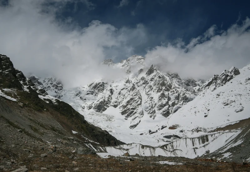
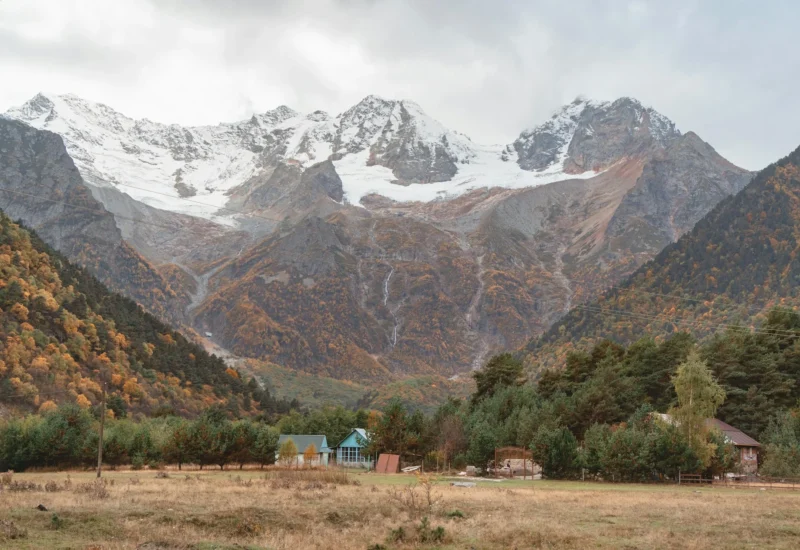
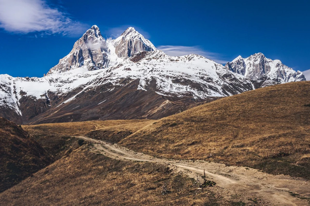
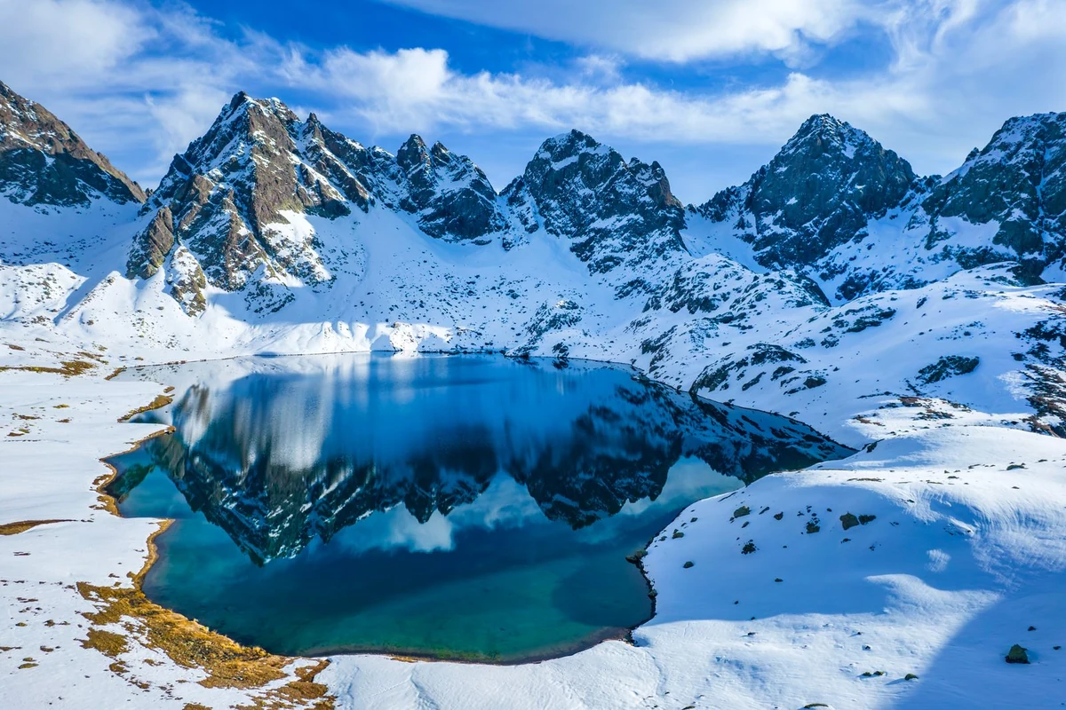
Koruldi Lakes sit at 2,740 m in the Tskhakvzagari mountains northwest of Mestia, about 10 km from town by road. Three small glacial lakes occupy a broad alpine plateau with open views across the Greater Caucasus — Mount Ushba to the south, Tetnuldi to the east, and the Enguri valley below. The Koruldi Lakes hike is one of the most popular day trips from Mestia and also one of the most physically demanding.
The trail gains roughly 1,400 m of elevation from Mestia’s town centre at 1,400 m. Most of that climb happens in the first half, on a steep path up to the Mestia Cross viewpoint at around 2,150 m. Above the Cross, the route follows a jeep track for another 1.5 hours to the lakes. The total round trip on foot is approximately 14 km and takes between 6 and 10 hours depending on your pace.
You can shorten the hike significantly by taking a 4×4 taxi from Mestia to the Cross, or all the way to the lakes. Both options are widely available and worth considering if you want to save time or energy for the upper section, where the views are.
Getting to the Trailhead
The hike starts at Seti Square in the centre of Mestia. From the square, follow the cobbled road uphill through Lanchvali village. The trail is marked with red and white rectangular blazes throughout the lower section. Look for a yellow sign pointing toward Koruldi Lakes near the town centre — follow that direction and keep ascending.
After roughly 500 m you will reach a junction with a wooden sign. Keep straight ahead rather than taking the fork to the right marked for the Mestia Cross jeep road. The path climbs through the village past several Svan tower houses, passing through a stone arch attached to one of them, before leaving the settlement and heading up open pasture.
| Navigation note: Google Maps does not reliably route to the lakes trailhead and may direct you to the Chalaadi Glacier road instead. Use Maps.me or follow the yellow trail signs from Seti Square on foot. GPX tracks are available on Transcaucasian Trail’s website and Gaia GPS. |
Hike vs. Jeep: Two Ways Up
You have two main options for getting to Koruldi Lakes, and most people who do the full hike combine them on the way up and down.
The full hike from Mestia covers about 7 km one way with 1,400 m of elevation gain. It is a hard day by any standard — the section from Mestia to the Cross involves a steep, unrelenting climb of around 800 m. Even experienced hikers find this stretch demanding. Allow 3–4 hours to reach the Cross, then another 1.5 hours to the lakes, and budget the same for the return.
The jeep option involves hiring a 4×4 taxi in Mestia to drive you up the mountain road to the Cross or directly to the lakes. The road from the Cross to the lakes is the same dirt track hikers use, so a jeep can reach the lakes in most conditions. Expect to pay around 100 GEL (~$36) per car to the Cross, or around 250 GEL (~$90) per car to the lakes and back. Prices are per vehicle, not per person — sharing with other guests from your guesthouse brings the cost down considerably. Drivers can be arranged through any guesthouse in Mestia.
| Practical tip: A popular approach is to take a jeep one way to the Cross and hike the rest. The climb from Mestia to the Cross is the steepest and least scenic section. Taking a jeep up and walking down gives you the views without the most punishing ascent. |
The Trail: Mestia to Koruldi Lakes
From Seti Square, the trail climbs steeply through forest and open meadow for about 2.75 km to the Mestia Cross at roughly 2,150 m. This section gains around 750–800 m and takes 2.5–3 hours. The path is marked and straightforward but relentlessly steep — there are no flat sections. The forest provides some shade for the lower part; above the treeline the trail is fully exposed.
At the Cross you reach a large viewpoint platform and a small café where you can rest, buy drinks, and look back down over Mestia and the Enguri Valley. The Svan towers in the town below are visible from here on clear days. Paragliders sometimes launch from the ridge just beyond the Cross.
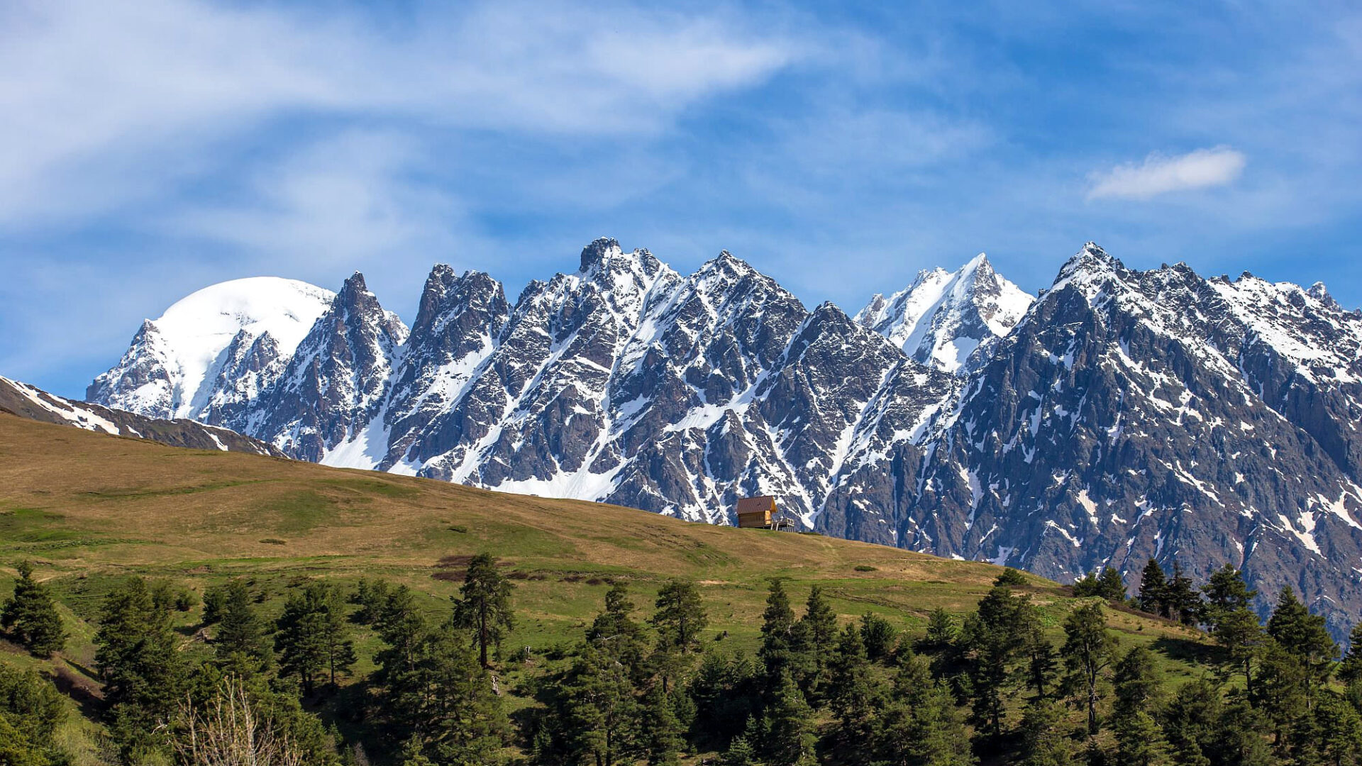
From the Cross, the trail joins the jeep track heading northwest. The gradient eases considerably and the route follows the dirt road with occasional shortcuts across alpine meadow. This section takes 1–1.5 hours. The lakes appear as you reach the broad plateau — three shallow pools set against a backdrop of glacier-topped ridges. The total elevation gain from Mestia to the lakes is approximately 1,340 m over 6.35 km.
The Cross Over Mestia Viewpoint
The Mestia Cross — also called the Jvari viewpoint or Tskhakvzagari Cross — sits at around 2,150 m and marks the midpoint of the hike. It is a worthwhile destination in itself and a popular short hike for people who do not want to continue to the lakes.
The wooden lookout tower at the Cross gives panoramic views south over Mestia town, the Mestiachala River valley, and the Svan towers that define the town’s skyline. On clear days the surrounding peaks are visible in multiple directions. The small café here is the last place to buy food or drinks before the lakes — there is nothing else on the upper trail.
From Mestia to the Cross alone is a 2.5-hour hike one way, covering 2.75 km with 750 m of elevation gain. If you only have a few hours and want a viewpoint without a full-day commitment, the Cross is a reasonable target.
What to Expect at the Lakes
The Koruldi Lakes are three small, shallow glacial pools on an open plateau at 2,740 m. The lakes themselves are modest in size — some visitors arrive expecting a dramatic highland lake and find the scale underwhelming. The main draw is the panorama: Mount Ushba’s twin peaks dominate the view to the south, with Tetnuldi visible to the east and the Laila and Shkhara ranges beyond. On a clear day the reflection of Ushba in the lakes is the defining image of the spot.
The upper plateau around the lakes is grazed by cattle and wild horses, which roam freely. Water from the stream below the lowest lake is available but should be treated before drinking — animals use the same water source.
For those wanting more, the Koruldi Ridge extends above the lakes to 3,300 m, requiring an additional 560 m of climbing from the lakes. The ridge scramble does not require technical equipment but involves exposed terrain and is not suitable for people with a fear of heights. It adds 2–3 hours to an already long day.
Best Time to Visit Koruldi Lakes
The trail is accessible from June through October. July and September are the most reliable months — the path is clear of snow, weather windows are longer, and afternoon cloud buildup is less severe. Late June can still have snow on the upper sections, and by late October the first autumn snowfalls are possible at altitude.
Avoid hiking in May — snow at the lakes level can be a metre deep and the trail becomes dangerous without the right footwear and navigation skills. Hikers in late May have reported the lakes still frozen and the upper trail invisible under snow.
Start early regardless of the month. Aim to leave Mestia by 7–8 AM. Cloud cover builds from midday on most summer days, often obscuring the peaks by early afternoon. The best light and the clearest views are in the morning. Starting early also gives you enough time to reach the lakes, spend an hour or two there, and descend before dark.
Camping at Koruldi Lakes
Wild camping at the lakes is permitted and a popular option for those who want to watch the sunset and sunrise from altitude. The plateau is flat and there is space for multiple tents. There are no facilities — no toilets, no huts, and no services of any kind above the small café at the Cross.
A water source runs below the lowest lake. Treat the water before drinking — livestock graze the area and use the same stream. Bring a filter or purification tablets. A camping stove for hot drinks is worth the extra weight given the cold nights at 2,740 m, even in summer.
CloudBase Hut sits on the route between the Cross and the lakes and occasionally offers shelter, though it primarily serves ski-touring guests in winter. Do not count on it being open. Bring a four-season sleeping bag or a warm three-season bag with extra insulation layers — temperatures drop sharply after sunset at this altitude.
| Weather note: Afternoon thunderstorms develop quickly at altitude in Svaneti. If you are camping and hear thunder building, descend from the exposed ridge. Lightning has struck the upper plateau area. Check the forecast the evening before. |
What to Bring
There is no shade above the treeline and no water source until the stream below the lakes. The entire upper section — from the Cross to the lakes and back — is fully exposed alpine terrain. Pack accordingly.
- Water — at least 2 litres per person; more if you are camping
- Food for a full day — nothing is available above the Cross café
- Trekking boots with ankle support — the steep lower section and loose rocks on the upper trail demand grip
- Trekking poles — strongly recommended for the steep descent from the Cross to Mestia
- Waterproof jacket — weather changes fast; afternoon rain is common
- Sun protection — hat, sunscreen, sunglasses; the plateau has no shade
- Warm layer — the lakes sit at 2,740 m and wind on the plateau is cold even in July
- Headlamp — if you start early or return late
- Offline maps — Maps.me or Gaia GPS with the GPX track downloaded before you go; mobile signal is unreliable above the Cross
Sources
- https://svaneti.org/en/destinations/koruldi-lakes
- https://www.caucasus-trekking.com/treks/hike-to-koruldi-lakes
- https://georgia.travel/koruldi-lakes
- https://www.beyond-the-known.eu/en/travel/2017/10/Georgia-Koruldi-lakes/
- https://georgia.to/en/things-to-do/sightseeing/koruldi-lakes-escape/
- https://transcaucasiantrail.org/en/hike/upper-svaneti-georgia/day-hikes-from-mestia/
- https://www.wildandwithout.com/2023/01/14/mestia-to-koruldi-lakes-camping-at-2700-meters/
authenticgeorgia.guide | Svaneti Hiking Guides