| Distance | ~50–75 km (depending on route) |
| Max elevation | 2,900 m (Eastern Toba Pass) |
| Lakes elevation | 2,545–2,650 m |
| Duration | 5–7 days (plus travel day) |
| Difficulty | Moderate to Hard |
| Season | Late July – mid-September |
| Starting point | Mukhuri village, Samegrelo |
| No mobile signal | Throughout the entire route |
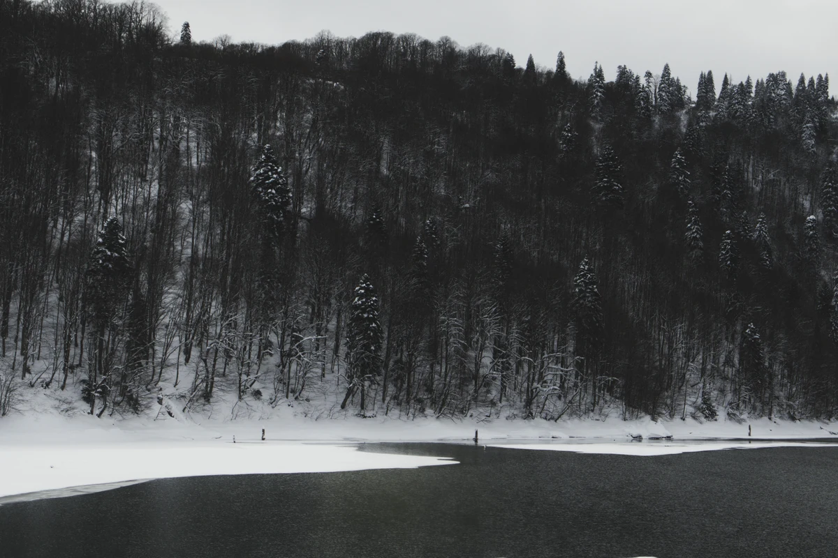
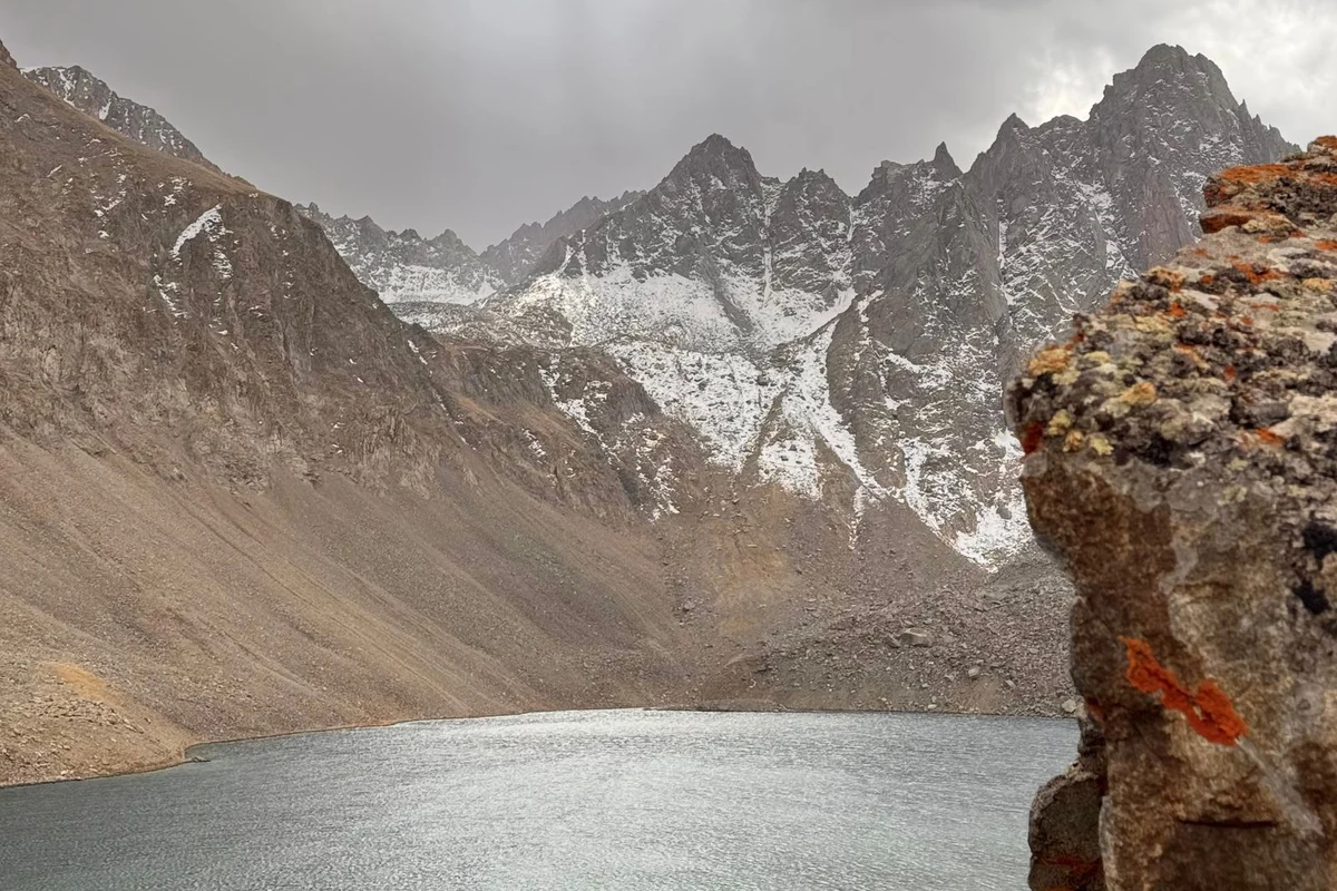
The Tobavarchkhili lakes sit in the Egrisi range of Samegrelo at between 2,545 and 2,650 metres above sea level. The name comes from old Megrelian and translates as “silver lakes” — a reference to the way the water mirrors the rocky peaks that ring each lake. Two main lakes form the core of the trek: the smaller Okhoje (also called Small Tobavarchkhili) and the larger Great Tobavarchkhili, locally known as Chitagvala’s Toba, meaning Red Mountain’s Lake.
Getting there is not easy. There are no guesthouses, no mobile signal, and no villages along the route. Once you leave the last shepherd huts, you are on your own for days at a time. That inaccessibility is part of what keeps the landscape in the condition it is: open alpine meadows, unmarked passes, clear glacial water, and a small community of nomadic shepherds who spend the summer season here with their herds.
This guide covers the main route from Mukhuri, what to expect on each section, how to get to the trailhead, and everything practical you need to plan the trip independently or decide whether to hire a guide. For an overview of the country’s other routes, see our guide to hiking in Georgia.
Tobavarchkhili Trek Routes
Three main routes lead to the lakes, each with a different character and difficulty level.
The Mukhuri route is the most popular and the most logical starting point for most hikers. It begins in Mukhuri village in Chkhorotsku Municipality and follows the Khobistskali river valley into the mountains. A 4WD road now runs as far as the Natipuru hut at around 1,900–2,000 m, and many hikers take a local truck for this first 25–35 km section, saving a full day of walking on an unsealed road with limited views. From Natipuru, the trail continues over the Okhoje Pass (2,750 m) and descends to the first lake.
The Skuri route is the shortest way in and out, entering from the south through the Magana valley. It is marked with red trail markers and can be completed in as few as two days from Skuri village near Zugdidi. It is the least scenic of the three options. Note: as of late 2024/2025, a landslide damaged this section near the Jolora campsite. The classic Mukhuri–Skuri through-route is currently not passable at that point; hikers wanting to exit via Skuri should use the Okare pass variant instead.
The Khaishi route approaches from the north, entering from Svaneti. It is the longest and most remote option and is suited to hikers who want to combine the Tobavarchkhili lakes with a Svaneti crossing. Expect difficult navigation in places — GPS is necessary.
The most common itinerary is a point-to-point trek from Mukhuri to Khaishi (or the reverse), which takes 5–7 hiking days and covers roughly 50–75 km depending on which sections you walk and which you cover by truck.
Tobavarchkhili Difficulty and What to Expect
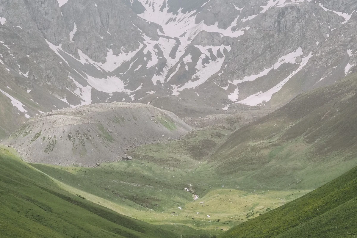
The trek is generally rated moderate to hard. Daily walking distances run from 4 to 14 km, with elevation gains and losses of 600–1,000 m on the harder days. The two main passes — Okhoje at 2,750 m and Eastern Toba at approximately 2,900–2,920 m — require a solid effort, especially if snow is still present on the northern slopes in late July. The route elevation stays mostly between 1,800 and 2,700 m, below the threshold where altitude sickness typically becomes a concern.
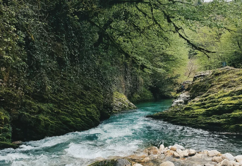
The terrain is varied: dense subtropical forest in the lower valleys, open alpine meadows higher up, rocky sections near both passes, and some narrow paths along valley walls where the footing requires attention. Several river crossings are involved, and water levels can be high in early summer or after heavy rain. The trail is non-technical — no climbing equipment required — but proper footwear and trekking poles make a significant difference.
There is no mobile phone coverage anywhere on the route. In an emergency, the nearest help is at the shepherd huts or at the end of the road accessible by truck. Factor this into your preparation — carry a basic first aid kit, and ensure someone not on the trip knows your itinerary.
| ⚠ Trail update (2024/2025): The section near Jolora campsite was damaged by a landslide. The standard Mukhuri–Skuri exit route is currently blocked. Hikers planning to finish in Skuri should use the Okare pass alternative. Check conditions before departing. |
Tobavarchkhili Best Time to Visit
The accessible season runs from roughly mid-June to mid-September, though the best window for stable conditions and snow-free passes is late July to mid-September. Attempting the trek in early July is possible but you may encounter significant snow on both passes, and river crossings will be higher due to snowmelt.
Daytime temperatures at lower elevations reach 15–25°C; at camp by the lakes, expect 5–15°C during the day and temperatures that can drop below freezing at night. Afternoon thunderstorms are common in July and August, particularly above 2,500 m. Fog can roll in quickly and persist for days — experienced hikers typically build at least one buffer day into their itinerary to wait out poor weather at the lake and get a clear-sky view.
The Egrisi range receives heavy rainfall due to its proximity to the Black Sea. Wet conditions are normal; plan for them rather than hoping to avoid them.
How to Get to Tobavarchkhili
The gateway to the Mukhuri route is Zugdidi, the main city of Samegrelo. From Tbilisi, marshrutkas and trains run to Zugdidi (roughly 5–6 hours). From Zugdidi, a marshrutka to Mukhuri departs at 9:00 am from the bus station near the bridge (coordinates: 42°30’31.9″N 41°52’09.0″E) — not the bus station by the train station. The ride costs around 3 GEL and takes over two hours. A taxi from Zugdidi to Mukhuri runs approximately 60–80 GEL (~$22–30 USD) and takes under an hour.
From Mukhuri, the first 25–35 km to the Natipuru trailhead is on rough off-road track. Local families in Mukhuri provide transport in Soviet-era URAL or 6×6 trucks — the only vehicles capable of handling the road. This costs approximately 300–400 GEL (~$110–145 USD) one way for the vehicle (not per person), making it worth sharing with a group. The drive takes 3–4 hours. Hiring a horse to carry gear from Natipuru is also possible; rates are roughly 50 GEL per horse per day, though locals may quote higher for foreign visitors — agree on the price upfront.
If you are exiting via Khaishi rather than returning to Mukhuri, marshrutkas connect Khaishi to Zugdidi and Mestia, but they run only a couple of times daily and are often full. Have a phone number for a taxi from Zugdidi as backup; expect to pay around 300 GEL for that ride.
Tobavarchkhili Self-Guided Hike vs Guided Tour
The Tobavarchkhili trek is doable independently, but it requires solid navigation skills. Parts of the route — particularly near the Khaishi exit and on some of the less-used variants — are unmarked and require GPS or a detailed map. The Mukhuri route is better trodden and has some trail markers, but does not have consistent signage throughout.
Going self-guided means carrying all food for the duration (5–7 days plus contingency), a tent, and a sleeping bag rated to at least 0 to -10°C. There are no resupply points once you leave Mukhuri. Horse rental reduces the load significantly for those who want it.
Guided tours typically include transport from Tbilisi, a truck to Natipuru, horse support for heavy gear, a cook, and a local guide with route knowledge. Prices vary, but expect to pay in the range of $200–$400 USD per person for a 6–9 day guided group tour depending on the operator and group size. Private tours are available at higher cost. The advantage of a guide is particularly notable in poor weather, when pass navigation becomes harder, and in knowing current trail conditions.
Tobavarchkhili Camping
The entire trek is wild camping — there are no guesthouses, mountain huts (apart from basic shepherd structures), or organised campsites. Bring a four-season tent or a three-season tent with a solid footprint, as winds can be strong and nights cold.
Good camping spots exist at several points along the route: near the Natipuru hut (approximately 1,900 m), by Okhoje/Small Tobavarchkhili lake (2,545 m), and by the Great Tobavarchkhili lake (2,650 m). Water is available from streams and the lakes themselves throughout the route — carry a filter or purification tablets as a precaution. Firewood is scarce above the tree line; a camping stove is essential.
The shepherd huts in the Magana valley offer an interesting stop — the families there have historically welcomed trekkers and sometimes sell or share dairy products and traditional Megrelian food including elarji (cornmeal with cheese) and sulguni. This is not guaranteed, so carry all your own food.
Tobavarchkhili Packing List
Gear that matters most on this trek:
- Sturdy waterproof hiking boots with ankle support
- Trekking poles (rocky terrain and river crossings)
- Waterproof jacket and trousers
- Warm mid-layer and hat — temperatures drop sharply at night above 2,500 m
- Tent (four-season or solid three-season)
- Sleeping bag rated to 0°C or lower
- Sleeping mat
- Camping stove and fuel
- 5–7 days of food plus one day’s emergency rations
- Water filter or purification tablets
- Offline GPS maps (Maps.me or similar — no phone signal on route)
- First aid kit including blister treatment
- Sun protection (UV is high at altitude)
| ⚠ Note: There is no mobile coverage anywhere on the trek. Download offline maps before leaving Zugdidi or Mukhuri, and share your itinerary with someone not on the trip. |
Egrisi Mountains: Silver Lakes and Surrounding Area
The two main Tobavarchkhili lakes are the focal points of the trek, but the area holds several smaller lakes worth the detour if conditions allow. Kaliashi lake is distinctive for its heart shape; Didi Ghele is typically partially frozen even in August; Tshakatskali requires a harder approach and is less frequently visited. From the ridges above the lakes, Elbrus — the highest peak in Europe at 5,642 m — is visible on clear days, as are the peaks of Svaneti. Chitagvala (3,225 m) is climbable for experienced scramblers (B-2 difficulty level).
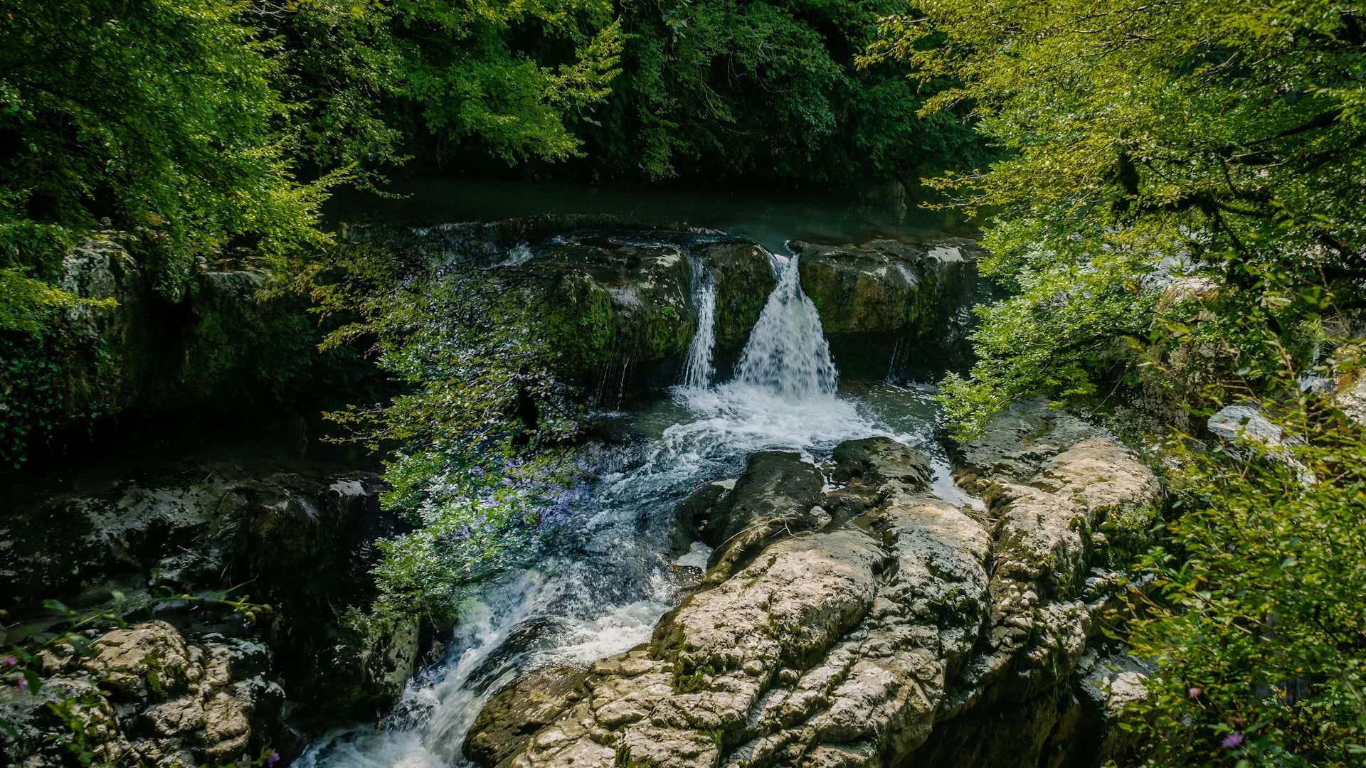
The Samegrelo region that the trek passes through is the homeland of the Megrelian people. Toba waterfall, encountered on the Magana valley descent, is one of the more photogenic features on the lower part of the route. The subtropical forest in the lower valleys — moss-covered rocks, wild hazelnut and blackberry — is a sharp contrast to the high alpine terrain above.
Sources
- caucasus-trekking.com — trek-to-tobavarchkhili-lakes
- georgia.travel — mukhuri-tobavarchkhili-lakes-khaishi
- trekgeorgia.com — tobavarchkhili-lakes
- georgiantour.com — toba
- transcaucasiantrail.org — day-15-tobavarchkhili-lakes-to-anaklia
- budget-georgia.com — tobavarchkhili-lakes-trek-guided-tour-from-tbilisi